19 Jul


Introducing the ME 120: A Smarter Way to Survey Water Bodies
Hydrographic surveying has entered a new era—one defined by precision, efficiency, and safety. The days of deploying large crewed vessels and dealing with complex logistics are giving way to compact, intelligent systems that do more with less.Meet the ME 120, a versatile Hydrographic Unmanned Surface Vehicle (USV) built for modern water surface and underwater bed surveys. Whether you're mapping an ocean shoreline, profiling a riverbed, or monitoring a lake or reservoir, the ME 120 is engineered to deliver high-accuracy data in even the most demanding environments.
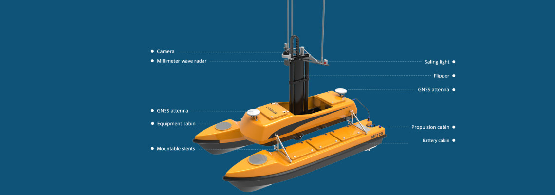
This isn’t just another survey robot. The ME 120 features a convertible catamaran hull—a stable, modular platform purpose-built for carrying precision sonar payloads and performing flawlessly on turbulent waters.
Benefits of a Catamaran?
The ME 120 stands out from traditional USVs thanks to its catamaran-style hull, which offers exceptional balance and stability on moving or "violent" water surfaces. This design dramatically reduces pitch and roll during operation, making it ideal for sensitive equipment such as echo sounders and acoustic sonars.Because hydrographic surveys rely heavily on consistent contact between the sensor and the water medium, even slight instability can degrade data quality. The catamaran platform of the ME 120 ensures smooth, vibration-free movement, enabling high-resolution data capture even in choppy conditions.
The hull is also convertible and modular, allowing the platform to adapt based on survey needs or payload configuration. It can be assembled or disassembled quickly for transport and storage, making it an ideal solution for remote or difficult-to-access survey sites.
Designed for Comprehensive Water Surveys
The ME 120 is capable of performing detailed surveys of both surface and subsurface features. It supports a range of missions including:Bathymetric mapping of lakes, rivers, reservoirs, and coastal zones
Environmental monitoring and water quality assessment
Port and harbor inspection
Dredging pre- and post-surveys
Floodplain analysis and disaster response
Infrastructure development and feasibility studies
Its autonomous capabilities allow for pre-programmed route navigation, while manual remote control remains available for fine maneuvering in tight or obstacle-rich environments. The ME 120 operates on rechargeable batteries, offering emission-free and quiet performance ideal for sensitive ecosystems and long-duration missions.
Flexible Payload Options for Tailored Surveys
The ME 120 supports a wide array of modular payloads, allowing users to customize the USV for specific survey requirements. Here’s a brief overview of its primary payload options:Singlebeam Echo Sounder (SBES):
Used for point-based depth measurement. Ideal for quick, shallow-water depth profiling or smaller-scale bathymetric projects.Multibeam Echo Sounder (MBES):
Captures a wide swath of high-resolution depth data in a single pass. Essential for detailed seafloor mapping, underwater construction planning, and dredging applications.Acoustic Doppler Current Profiler (ADCP):
Measures the speed and direction of water currents at different depths. Useful for hydrodynamic modeling, sediment transport studies, and flood analysis.Side-Scan Sonar:
Generates high-resolution images of the underwater environment. Ideal for object detection, habitat mapping, and pipeline or cable inspection.GNSS + RTK Positioning:
Provides centimeter-level positioning accuracy to support precise georeferencing of sonar data. Critical for any professional hydrographic survey.Water Quality Sensors:
Measures key environmental parameters such as temperature, pH, turbidity, dissolved oxygen, and conductivity. Suitable for pollution tracking, ecological research, and regulatory compliance.Optional HD Camera System:
Captures surface-level imagery for visual inspection and documentation. Often used in tandem with sonar data to provide a complete overview of survey conditions.Each payload integrates seamlessly with the ME 120’s onboard data acquisition system, with live telemetry available via Wi-Fi, 4G, or long-range radio. Data can be processed in real-time or stored for post-survey analysis, depending on the needs of the project.
A Future-Proof Investment in Survey Efficiency
The ME 120 is designed not just for accuracy, but also for convenience and scalability. Its compact, portable structure allows for single-person deployment, and its intuitive control system reduces training requirements and accelerates field readiness.With minimal maintenance needs and a robust build suitable for both freshwater and marine environments, the ME 120 delivers long-term value and adaptability for evolving survey challenges.
Real-World Benefits
Faster data collection compared to manual or crewed methodsReduced operational cost by eliminating the need for large survey boats
Enhanced safety by keeping personnel off hazardous water bodies
Greater precision through stable sonar platform and RTK positioning
Eco-friendly operation with zero emissions and minimal noise pollution
Ready to Redefine Your Hydrographic Surveys?
Whether you're a marine contractor, government agency, environmental researcher, or engineering firm, the ME 120 Hydrographic USV is built to simplify your work and amplify your results.Contact our team today to schedule a live demo or receive a tailored proposal. With the ME 120, hydrographic surveying becomes smarter, safer, and significantly more efficient.


