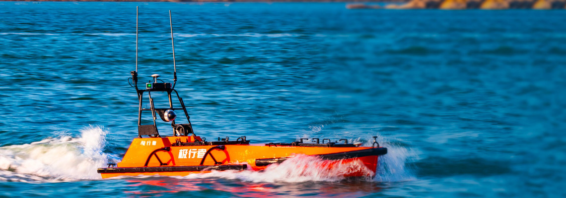
Introducing - M 80
"the Autonomous Survey Boat"
Powering Precision in Hydrographic Surveys
In today’s marine and inland water surveying
landscape, accuracy, reliability, and efficiency are non-negotiable. Surveyors
need platforms that can perform over long durations, adapt to changing
conditions, and deliver high-resolution data without costly manpower or
large-scale vessels.
Enter the M
80 Autonomous Survey Boat—a cutting-edge Unmanned Surface Vehicle (USV) engineered for extended
missions and built to handle the full spectrum of hydrographic surveying needs. Whether you're conducting
inshore bathymetric mapping, large-scale offshore assessments, or routine
inspection of inland water bodies, the M 80 is your trusted, all-weather,
autonomous partner.
Long-Endurance, Multi-Functional, and Mission-Ready
The M 80 is designed as a long-endurance, multi-functional survey platform,
capable of operating in oceans, rivers, lakes, reservoirs, and coastal
environments. Its advanced autonomous navigation system and robust marine
engineering enable the boat to remain in operation for extended periods without
interruption—making it ideal for large survey grids and missions in remote or
hard-to-reach locations.
With an intelligent control system and
multiple communication options, the M 80 supports both fully autonomous and
remotely piloted operations. This flexibility gives survey teams the ability to
deploy quickly, reduce labor overhead, and significantly increase operational
safety by eliminating the need to place crews on potentially hazardous waters.
Built for Professional Hydrographic Applications
The M 80 is tailored for a wide range of
surveying tasks, including:
·
Bathymetric surveys for ports, rivers, and
offshore installations
·
Pre- and post-dredging assessments
·
Pipeline and cable route inspections
·
Seabed classification and sediment studies
·
Floodplain mapping and waterway modeling
·
Coastal zone monitoring
·
Environmental and compliance-based water surveys
Its stable hull design, hydrodynamic
efficiency, and large payload capacity make it well-suited for
professional-grade sensors. The vessel maintains consistent heading and speed
during data collection, ensuring accurate, reliable results even in challenging
water and weather conditions.
Payload Flexibility to Match Every Mission
The M 80’s true strength lies in its ability
to carry a wide range of modular payloads. These integrated sensors allow the
platform to collect various types of hydrological, geophysical, and
environmental data—all in a single mission, if needed.
Multibeam
Echo Sounder (MBES):
This high-resolution sonar system captures detailed 3D imagery of the
underwater terrain. It is essential for comprehensive seabed mapping, dredging
verification, and offshore construction planning.
Singlebeam
Echo Sounder (SBES):
A simple yet effective sonar tool used for depth sounding and basic bathymetric
profiles. Ideal for smaller-scale or shallow-water surveys where fast
deployment is required.
Side-Scan
Sonar:
This payload creates acoustic images of the seafloor and submerged objects. It
is invaluable for detecting underwater hazards, mapping seafloor features, and
conducting habitat assessments.
Acoustic
Doppler Current Profiler (ADCP):
An instrument that measures current velocities across different depths. It is
used in hydrodynamic modeling, sediment transport analysis, and understanding
flow patterns near critical infrastructure.
Sub-Bottom
Profiler (SBP):
Enables visualization of subsurface sediment layers beneath the seabed. It
supports geotechnical assessments and pre-construction evaluations for offshore
installations.
RTK GNSS
Navigation System:
Equipped with real-time kinematic positioning technology, the M 80 delivers
centimeter-level location accuracy. This is essential for precise survey data
alignment and geo-referencing.
Water
Quality Sensors:
These optional sensors monitor key environmental parameters such as turbidity,
temperature, pH, dissolved oxygen, and conductivity. Suitable for environmental
impact assessments and compliance monitoring.
All payloads are seamlessly integrated with
the M 80’s onboard systems, ensuring synchronized data capture and real-time
monitoring. Data is transmitted to the control center or stored locally for
post-processing and detailed analysis.
Redefining Surveying Efficiency and Safety
With the M 80 Autonomous Survey Boat, survey
teams can achieve more—faster and safer than ever before. Its key advantages
include:
·
Extended endurance for long survey missions
without recharge or refueling
·
High-precision autonomous navigation with route
planning and obstacle avoidance
·
Reduced operational costs due to unmanned
deployment
·
Greater safety by removing personnel from dangerous
or remote waters
·
Compatibility with a wide range of hydrographic
and environmental sensors
·
Compact design for easy transport and deployment
in the field
Whether you are operating in inland waters,
estuarine environments, or offshore zones, the M 80 is built to endure, adapt,
and excel.
Trusted by Professionals Across Industries
The M 80 is an ideal solution for hydrographic
survey companies, engineering consultants, offshore energy developers,
environmental monitoring agencies, government hydrology departments, and
research institutions. It empowers professionals with the tools they need to
complete complex surveys with confidence, speed, and accuracy.
Discover the M 80 Advantage
The M 80 Autonomous Survey Boat is the future
of hydrographic surveying—autonomous, precise, and built for performance. If
you're ready to modernize your marine data acquisition process and maximize
your field efficiency, the M 80 is ready to deliver.


