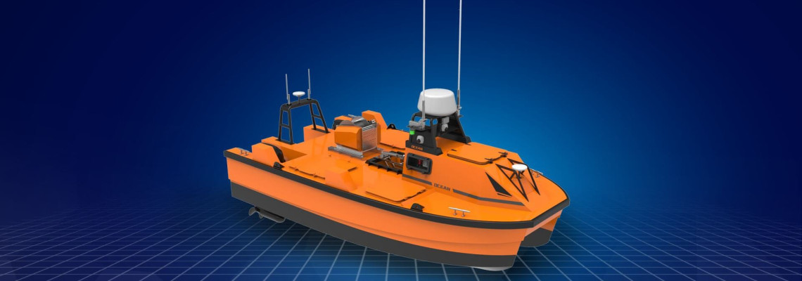
Unlock New Surveying Potential with the M 40 P Hydrographic USV
In the world of marine construction, offshore
energy, and environmental science, accurate and efficient data collection is
vital. Traditional methods involving large crewed vessels are not only
expensive and time-consuming but also expose operators to unnecessary risks in
complex marine environments.
Enter the M
40 P—a Hydrographic Unmanned
Surface Vehicle (USV) designed to perform high-precision surveys
across oceans, estuaries, lakes, rivers, and other water bodies. Whether you're
surveying the bed of a coastal zone or conducting pre-installation studies for
offshore infrastructure, the M 40 P is built to deliver performance you can
rely on.
A Multi-Purpose USV Platform for Dynamic
Marine Applications
The M 40 P is more than just a survey
tool—it’s a versatile, purpose-built USV
platform that adapts to various hydrographic and geophysical missions.
From shallow estuaries to deeper offshore environments, this compact yet
powerful vessel ensures dependable data acquisition for a wide range of
industries.
It is particularly suited for:
·
Offshore wind farm site surveys and maintenance
·
Oil and gas exploration and construction support
·
Coastal engineering and port development
·
River and estuary monitoring
·
Environmental impact assessments
·
Subsea infrastructure inspection
·
Dredging projects and underwater topography
analysis
Thanks to its robust marine-grade construction
and modular design, the M 40 P performs seamlessly in both near-shore and
offshore environments, withstanding harsh conditions while maintaining
survey-grade precision.
Built for the Offshore Challenge
The M 40 P is engineered to meet the demanding
requirements of construction planning and
routine maintenance in offshore industries. In wind farm and oil &
gas operations, data accuracy is critical—not just during the design phase but
throughout the lifecycle of infrastructure.
This USV allows organizations to perform
high-resolution seabed mapping, pipeline routing surveys, scour monitoring, and
site condition assessments—without the need for large, crewed vessels. With autonomous
navigation and remote operation capabilities, the M 40 P reduces operational
costs, minimizes risk, and enhances field productivity.
Its compact size and efficient propulsion make
it easily deployable from small boats or dockside facilities, allowing for
rapid mobilization and minimal logistical burden.
Payload Capabilities: Modular and
Mission-Ready
The M 40 P supports a diverse range of
high-precision sensors and instruments, enabling operators to tailor the platform
to specific survey objectives. Here's a brief overview of its core payloads:
Multibeam
Echo Sounder (MBES):
Provides high-resolution, wide-swath bathymetric data for detailed seabed
mapping. Ideal for offshore construction, cable/pipeline routing, and
pre/post-dredging surveys.
Singlebeam
Echo Sounder (SBES):
Used for point-specific depth measurements, particularly in shallow water
zones. Offers a lightweight and cost-effective solution for rapid surveys.
Side-Scan
Sonar:
Delivers acoustic images of the seafloor and submerged objects. Crucial for
seabed classification, habitat mapping, and locating underwater hazards.
Acoustic
Doppler Current Profiler (ADCP):
Measures water current profiles at multiple depths. Valuable for understanding
current patterns affecting offshore structures and sediment transport.
Sub-Bottom
Profiler (SBP):
Reveals sediment layers and geological features beneath the seabed. Essential
for geotechnical studies in offshore wind and oil platform development.
GNSS +
RTK Positioning System:
Ensures centimeter-level accuracy for all georeferenced data. Critical for
aligning survey results with onshore construction grids or marine navigation
systems.
Water
Quality Sensors:
Monitors environmental parameters such as temperature, pH, turbidity, dissolved
oxygen, and salinity. Useful for environmental baseline studies and compliance
monitoring.
All sensors are fully integrated with the
vessel's navigation and data acquisition system, ensuring synchronized,
reliable outputs. Real-time telemetry allows survey teams to monitor operations
remotely and adjust missions as needed on the fly.
Operational Benefits You Can Trust
The M 40 P offers numerous advantages over
traditional survey methods:
·
Reduces dependency on manned vessels, cutting
fuel and labor costs
·
Enhances safety by removing personnel from
hazardous offshore zones
·
Increases survey speed and efficiency through
autonomous or semi-autonomous modes
·
Ensures data accuracy and consistency, even in
challenging weather or sea states
·
Provides flexible deployment options for a wide
variety of marine environments
Whether you're launching from the coast or
operating far offshore, the M 40 P delivers a balance of portability,
endurance, and precision that few platforms can match.
Empowering Your Marine Operations
For survey firms, engineering consultants,
offshore energy providers, and environmental agencies, the M 40 P represents a
smart investment in technology that saves time, reduces risk, and improves data
quality.
With its modular payload options and rugged
versatility, this USV is the perfect fit for professionals who demand reliable
performance in dynamic marine conditions.
Get Started with the M 40 P
If you're planning a hydrographic survey or
preparing for offshore construction, the M 40 P Hydrographic USV is your go-to
solution for efficient, cost-effective, and high-quality data acquisition.
Contact us today to
schedule a demo, request a quote, or learn how the M 40 P can be customized for
your next mission.
The future of marine surveying is here—and it’s unmanned, precise, and ready to
deploy.


